


An analysis commissioned by the Bertarelli Foundation and The Pew Charitable Trusts found that Easter Island’s marine environment to be one of the most unique in the world. Due in part to its remote location and vast size, Easter Island’s waters are potentially vulnerable to illegal fishing—a criminal activity dependent on the perception that “no one is watching.”
The Rapa Nui community has long claimed that foreign vessels are fishing illegally in their waters and local fishermen have reported seeing, what they believe to be, fishing vessel lights in their waters at night; buoys and long line nets, which they don’t use, have often been found washed ashore.
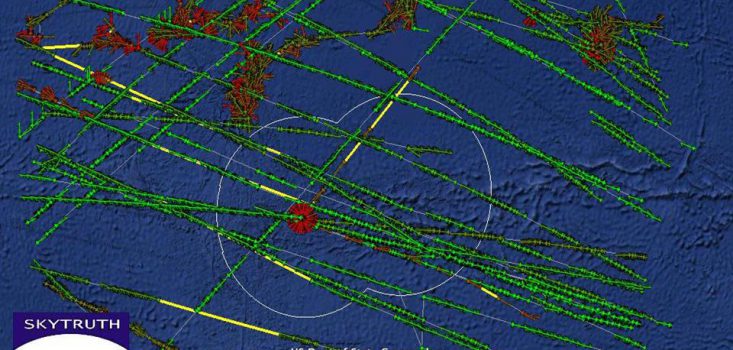
The Bertarelli Foundation enlisted the help of SkyTruth, a U.S.-based non-profit organisation specializing in satellite-based remote sensing technologies, to monitor via satellite Easter Island’s waters. Using two different satellite technologies—Automatic Identification System (AIS) and Synthetic Aperture Radar (SAR)—the information collected enabled suspected illegal fishing occurring far out at sea and over a vast area of water to be pinpointed with incredible accuracy.
From January to December 2013, they collected information about most of the commercial maritime traffic, including numerous commercial-scale fishing vessels, passing through the more than 700,000 square kilometer marine area that surrounds Easter Island Province. It is believed that this is the first time that these satellite technologies have been combined in this way and used to monitor a country’s waters for illegal fishing activity.
With data collected through October 2013, including 163 satellite images, 73 vessels were detected in and around Easter Island’s waters. Of these, 31 were identified using AIS (22 cargo ships, 5 fishing vessels, 1 cruise ship, and 3 undefined). More than half (the remaining 42 vessels) did not identify themselves using AIS, and – based on their size and location – were determined by SkyTruth to be commercial fishing vessels. Twenty-five of these vessels were detected within Easter Island’s Exclusive Economic Zone.
The evidence collected so far suggests that unidentified commercial fishing vessels are operating in Easter Island waters, possibly engaged in illegal fishing activity. There is more work to be done to determine the extent of the problem and so the Bertarelli Foundation has committed to a further six months of monitoring in order to further pinpoint when and where possible illegal fishing is occurring in Easter Island’s waters.